 |
ANTIQUE MAPS OF WORCESTERSHIRE AT
|
ANTIQUE MAPS OF WORCESTERSHIRE | |
| CLICK ON REFRESH/RELOAD TO ENSURE YOU HAVE THE UPDATED VERSION OF THIS PAGE | |
|
HALL, Selina, fl.1831-1853 : WORCESTER SHIRE. London : Chapman & Hall, 1833. A charming map of the county originally issued with the John Gorton part-work “A Topographical Dictionary of Great Britain and Ireland”. The maps in this series are generally credited to Sidney Hall (1788?-1831), but maps towards the end of the series were in fact prepared and engraved by his widow and successor, Selina Hall – who silently continued the business for upwards of twenty years under the quasi-pseudonymous style of “S. Hall” – the maps continuing to be credited to her late husband. £50 To purchase, call us or e-mail us at maps@ashrare.com quoting stock number 38450 – or simply click on the button
|
 |
MORDEN, Robert, fl.1668-1703 : WORCESTER SHIRE. [London] : sold by Abel Swale, Awnsham & Iohn Churchil, [1722]. A handsome antique map by the London mapmaker Robert Morden. When they were first published in 1695, Morden’s county maps were advertised as being “much the fairest and most correct of any that have yet appear’d”. The help of “knowing gentlemen” in each county had been sought “to supply the defects, rectifie the positions, and correct false spellings”. Originally produced for the 1695 edition of “Camden’s Britannia”. Further corrections were made for this second edition of 1722. £150 To purchase, call us or e-mail us at maps@ashrare.com quoting stock number 13707 – or simply click on the button
|
 |
[MOULE, Thomas, 1784-1851] : WORCESTERSHIRE. [London : George Virtue, 1831]. A most attractive “gothick” map of the county, bordered with vine-leaves, coats of arms, and inset views of Great Malvern, Worcester, and Croom or Croome Court. Originally engraved by James Bingley (1796-1869) in 1831 for Moule’s part-work series “The English Counties Delineated” (1830-1837) – and here in very early state, before the later additions. £100 To purchase, call us or e-mail us at maps@ashrare.com quoting stock number 43956 – or simply click on the button
|
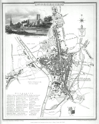 |
YOUNG, George, 1750-1820 : WORCESTER. London : Vernor, Hood & Sharpe, 1808. A neatly worked and detailed town plan of Worcester as it stood in the early years of the nineteenth century. Engraved by John Roper (1771-1810) from a draught by the local land surveyor George Young. The map is decorated with the coats of arms of both the City and the See of Worcester, as well as a charming vignette view of the cathedral – the latter separately engraved by James Sargant Storer (1771-1853) from an original study by Edward Dayes (1763-1809). Originally produced to accompany the part-work “Beauties of England and Wales” (London : 1801-1818). £100 To purchase, call us or e-mail us at maps@ashrare.com quoting stock number 43150 – or simply click on the button
|
| |
Return to Ash Rare Books home page. | |
