 |
ANTIQUE MAPS OF THE THAMES AT
|
ANTIQUE MAPS OF THE RIVER THAMES | |
| CLICK ON REFRESH/RELOAD TO ENSURE YOU HAVE THE UPDATED VERSION OF THIS PAGE | |
   |
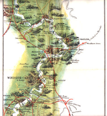
BENNET, J.F. (John Frederick), 1852-1937 – publisher : UP AND DOWN THE RIVER. BENNET’S MAP & ABC GUIDE TO THE RIVER THAMES FROM OXFORD TO GRAVESEND WITH USEFUL NOTES FOR BOATING AND ANGLING. London : J. F. Bennet, 1892. Sixth edition. A popular and attractive map of the best-known stretch of Thames, produced by the City of London printer and stationer, John Frederick Bennet of Queen Street, manufacturer of “Wryte-eezy” stationery, and whose shop is illustrated among the numerous and entertaining advertisements. The map is accompanied by twenty pages of text, with notes on angling, boating, steam-launches, locks and tolls, with a distance-table, and an A-Z guide to the riverside towns and villages. First published in 1889. £200 To purchase, call us or e-mail us at maps@ashrare.com quoting stock number 43146 – or simply click on the button
|
  |
BENNET, J.F. (John Frederick), 1852-1937 – publisher : UP AND DOWN THE RIVER. BENNET’S MAP & ABC GUIDE TO THE RIVER THAMES FROM OXFORD TO GRAVESEND WITH USEFUL NOTES FOR BOATING AND ANGLING. London : J. F. Bennet, 1907. Twenty-first edition. A popular and attractive map of the best-known stretch of Thames, produced by the City of London printer and stationer, John Frederick Bennet of Queen Street, manufacturer of “Wryte-eezy” stationery, which is advertised and illustrated among the numerous and entertaining advertisements. The map is accompanied by twenty pages of text, with notes on angling, boating, steam-launches, locks and tolls, with a distance-table, and an A-Z guide to the riverside towns and villages. First published in 1889. £100 To purchase, call us or e-mail us at maps@ashrare.com quoting stock number 43659 – or simply click on the button
|
 |
BOWRING PETROLEUM CO. – publishers : MEX MOTOR SPIRIT MAP OF THE RIVER THAMES. London : Bowring Petroleum Co., [ca.1917]. An attractive pocket atlas of the Thames, comprising a double-page general map and twenty-eight sectional maps covering the Thames from Westminster Bridge to Cricklade, with a further sectional map showing the Thames and Severn Canal as far as Trewsbury House near Kemble. Four pages of text add material on the 1914 Bye-Laws affecting motor launches and a brief history of Mex Motor Spirit – helping the allies to victory in “the present great War”. £75 To purchase, call us or e-mail us at books@ashrare.com quoting stock number 28692 – or simply click on the button
|
|
STANFORD, Edward, 1827-1904 : STANFORD’S MAP OF THE RIVER THAMES FROM RICHMOND TO LECHLADE. London : Edward Stanford, (1947). A folding coloured map of the Upper Thames at a scale of 1-1/2 (3.8cm) inches to the mile. Some rather forlorn inked annotation records a voyage from Taplow to Chertsey – “Engine Stopped” (Boveney), “Engine Failed” (Laleham), “Ron’s Prang” (Chertsey). £40 To purchase, call us or e-mail us at maps@ashrare.com quoting stock number 15316 – or simply click on the button
|
 |
TEMPLE THOMSON & CLARK : THAMES WHARVES. London : J. D. Potter, [ca.1905]. A striking and unusual map displaying (in two portions) the stretch of the tidal Thames from Charing Cross to Gravesend – the upper portion going downstream to Barking Reach, the larger lower portion from Halfway Reach on to Gravesend. At a scale of four inches to one sea mile, the principal feature is the identification in red of over 180 steamship wharves, with notes on vessel lengths, average spring and neap depths, etc. Compiled by the steamship owners and brokers Temple, Thomson & Clark, from their address at 38 Leadenhall Street – premises they appear to have occupied for a short while either side of 1905 – and published by the nautical equipment firm established by John Dennett Potter of the Minories. £400 To purchase, call us or e-mail us at maps@ashrare.com quoting stock number 42891 – or simply click on the button
|
| |
Return to Ash Rare Books home page. | |
