 |
ANTIQUE MAPS OF SCOTLAND AT
|
ANTIQUE MAPS OF SCOTLAND | |
| CLICK ON REFRESH/RELOAD TO ENSURE YOU HAVE THE UPDATED VERSION OF THIS PAGE | |
 |
DORRET, James, fl.1744-1761 : A CORRECT MAP OF SCOTLAND FROM NEW SURVEYS. [Edinburgh? : G. Hamilton & J. Balfour, and A. Kincaid?], 1751. A single-sheet reduction of Dorret’s 1750 wall-map of Scotland - “a greatly improved map ... the basis of practically every map of Scotland for the next forty years ... for the first time a really good outline becomes available” (Moir). Drawn and engraved by Dorret at a scale of ten miles to the inch (1:6336), with a separate inset of the Shetland Isles. No publication details are given, but the earlier wall-map was advertised in Scotland by the Edinburgh booksellers Hamilton, Balfour and Alexander Kincaid, and they may perhaps be responsible for this smaller version. £500 To purchase, call us or e-mail us at maps@ashrare.com quoting stock number 45378 – or simply click on the button
|
|
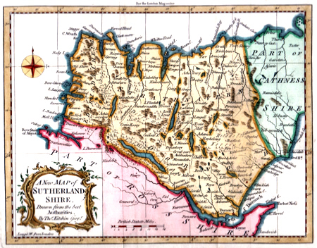
KITCHIN, Thomas, 1719-1784 : A NEW MAP OF SUTHERLAND SHIRE, DRAWN FROM THE BEST AUTHORITIES. [London] : for the London Magazine, [1764]. A charming antique map of the most remote corner of mainland Scotland as it was known in the eighteenth century – one of a series originally produced by Kitchin for the “London Magazine : or, Gentleman’s Monthly Intelligencer”. The present map first appeared with the August 1764 issue of magazine. £100 To purchase, call us or e-mail us at maps@ashrare.com quoting stock number 30825 – or simply click on the button
|
 |
ORDNANCE SURVEY : ORDNANCE SURVEY OF SCOTLAND : ARRAN – SHEET 21. Southampton : Ordnance Survey Office, 1870. A handsome one-inch map of the Isle of Arran, with portions of the adjacent coastlines of the mainland. Engraved by Henry Baker and John Darling and originally published in November 1870, with the present map printed from an electrotype taken in that year. £100 To purchase, call us or e-mail us at maps@ashrare.com quoting stock number 39141 – or simply click on the button
|
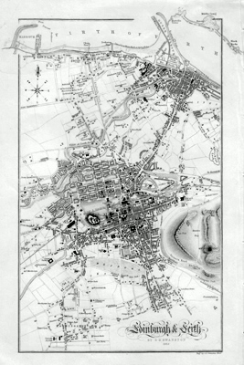 |
SWANSTON, George Heriot, fl.1841-1860 : EDINBURGH & LEITH. London & Edinburgh : A. Fullarton & Co., 1852. An attractive and delicately engraved plan of Edinburgh and Leith in the mid nineteenth century. Drawn and engraved by the Edinburgh engraver George Heriot Swanston and originally produced for Fullarton’s serially published “A Gazetteer of the World” (1850-1856). SOLD |
 |
WYLD, James, 1790-1836 - publisher : AINSLIES TRAVELLING MAP OF SCOTLAND SHEWING THE DISTANCES FROM ONE STAGE TO ANOTHER. London : James Wyld, 1830. A late, seemingly unrecorded, and much revised edition of the map first published by John Ainslie (1745-1828) in 1783. A crystal-clear road map of Scotland on a scale of around fourteen miles to the inch (1:8621), with mileages shown along each road, a triangular distance table for the major towns, and a table of spot-heights for the hills, etc. Wyld has added numerous new roads, especially in the Highlands, considerably extended the table of heights, and added a table of comparable English figures. £250 To purchase, call us or e-mail us at maps@ashrare.com quoting stock number 45379 – or simply click on the button
|
| |
Return to Ash Rare Books home page. | |
